GPS
Stands for "Global Positioning System."
GPS is a satellite navigation system used to determine the ground position of an object. Many commercial products, such as automobiles, smartphones, and GIS devices, include built-in GPS receivers. For civilian use, the system can accurately pinpoint a device within 16 feet (5 meters); specialized devices for land surveying and other government use are accurate within a few inches.
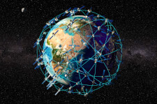
The GPS system includes more than 30 satellites (24 active and several backups) deployed in space about 12,000 miles (19,300 kilometers) above the earth's surface. They orbit the earth once every 12 hours at roughly 7,000 miles per hour (11,200 kilometers per hour). The satellites are evenly spread out so that four satellites are accessible via direct line-of-sight from anywhere on the globe.
Each GPS satellite broadcasts a message that includes the satellite's current position, orbit, and exact time. A GPS receiver combines the broadcasts from multiple satellites to calculate its exact position using a process called triangulation. Three satellites are required to determine a receiver's location, though a connection to four satellites provides greater accuracy.
For a GPS device to work correctly, it must first establish a connection to the required number of satellites. This process can take anywhere from a few seconds to a few minutes, depending on the strength of the receiver. For example, a car's GPS unit will typically establish a GPS connection faster than the receiver in a watch or smartphone. Most GPS devices also use some type of location caching to speed up GPS detection. By memorizing its previous location, a GPS device can quickly determine what satellites will be available the next time it scans for a GPS signal.

NOTE: Since GPS receivers require a relatively unobstructed path to space, GPS technology is not ideal for indoor use. Smartphones, tablets, and other mobile devices often use other means to determine location, such as nearby cell towers and public Wi-Fi signals. This technology, sometimes referred to as the local positioning system (LPS), is often used to supplement GPS when a consistent satellite connection is unavailable.
 Test Your Knowledge